Search Maryland Death Records
 Maryland Newspapers, Full Search (1728-1963), 234 titles
- Maryland Obituary Search, (1990-current)
- Maryland Birth Records Database, (1767-1963)
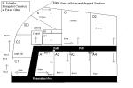 |
| Click map to enlarge |
Saint John the Evangelist Cemetery
Forest Glen, Montgomery County, Maryland
9700 Rosensteel Avenue
Silver Spring, Maryland 20910
Lat: 39° 00' 54"N, Lon: 77° 03' 06"W
Contributed by Robert Tebow, Oct 27, 2003 [dtebow@comcast.net]. Total records = 1,044.
From Georgia Ave, take Forest Glen Rd west to Rosensteel Ave, you will see the cemetery on the northwest corner of Forest Glen and Rosensteel. Turn right on Rosensteel Avenue.
The cemetery dates back to the 18th century and was originally the private Darnall/Carroll family plot. Today it is maintained by Gate of Heaven Cemetery which has records of the new section begun after 1978 that has metal grave markers flush with the ground. A record of the old section was made by members of Boy Scout Troop 466 as Robert Tebow's Eagle Scout project in 2003. They worked from notes from the early 1960s left by two ladies from St. John's parish, Mrs. Phyllis Falcao and Mrs.Mary Creeden. Rob Tebow and his volunteers entered the information in a database and created a map dividing the cemetery into 13 sections.
Orient yourself by facing the asphalt path leading from Rosensteel Avenue to the chapel. The A sections are on the right. A1 row 1 begins where the path turns to the right in front of the chapel and ends with a small stone block next to the path inscribed with a W, A2 ends at a double set of stone blocks next to the path, and A3 ends at the block marked Boyle. The C sections are to the left of the path and begin near the entrance at Forest Glen. C continues up the path, past the chapel on the left, and behind the chapel, ending in C3 in the vicinity of the small Gilson/Sorensen enclosure. The B section is to the right of the chapel, beginning with B1 which is enclosed by an iron fence and ending with the small enclosure of B3. D1 and D2 are to the right of the B section. E is the large, somewhat sprawling section beginning in the far left corner beyond C3 nearest to Forest Glen Road and backing up to the new section. Each grave is identified by the section, row number and grave number. When you find the section of the grave you are looking for, count rows as indicated in the record and count along the row to the grave number indicated. In the case of some of the large family markers, graves are all listed by a single plot number, even if there are individual stones or they appear to be in two separate rows.
Some markers are gone, others sunken in the ground or overturned, and, as a result, the only record that a person was buried in the cemetery is from the notes of the 1960s which have no indication of location. In addition, some markers were disturbed by a tree uprooted during Hurricane Isabel in 2003.
This transcription was compiled by myself and my BSA Troop 466 for my Eagle Scout project.
- Robert Tebow
Records Index: