Search Death Records (United States)
 U.S. Newspapers, 50 State Full Search (1690-present)
- U.S. Obituary Database Search, (1696-present)
- U.S. Birth Announcements Database, (1700s-present)
 |
| Click photo to enlarge |
 |
| Click photo to enlarge |
 |
| Click photo to enlarge |
 |
| Click photo to enlarge |
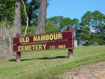
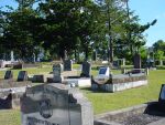
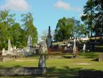
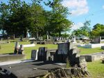
Nambour General Cemetery
Maroochy Shire, Queensland, Australia
Lat: 25° 36' 55"S, Lon: 152° 57' 24"E
Contributed by Joy Byrne (deceased)
submitted: Mar 10, 2000, last edited Jun 30, 2009.
Total records = 2,174.
Nambour is approximately one hour's drive north of Brisbane. One needs to deviate from the motorway as the town has been by-passed. It is quickest reached by taking the Bli Bli exit from the motorway, and turning right at the traffic lights.
The town is hilly and in the centre of a rich farming belt, sugar cane and fruit. There is a sugar mill in the town, and the cane trains cross the main street. Maroochy shire chambers are still sited here. The general cemetery was established in 1893, on the Nambour Connection Road.
Records for Old Nambour Cemetery are held at the Kulangoor Cemetery Office, which is on the northern outskirts of Nambour on Ackermann Road.
- Joy Byrne
Cemetery Records