Search Death Records (United States)
 U.S. Newspapers, 50 State Full Search (1690-present)
- U.S. Obituary Database Search, (1696-present)
- U.S. Birth Announcements Database, (1700s-present)
 Using
a GPS Device
Using
a GPS Device
Steve Paul Johnson
January 8, 2001
My wife and I, along with a friend of ours, were deep in the southeastern California desert in search of a small cemetery used by workers of the Southern Pacific Railroad during the late 1800s. It was called "Amos Cemetery", and we were told it was about 14 miles north of Glamis along the Ted Kipf road.
So along we drove, stirring up dust and sand in our 4x4s in search of this place. We finally had to stop and ask a group of dirt bikers if they knew where it was. They told us we had overshot it about a mile back. We went back and finally found it.
When I got back home, I downloaded the photos into my laptop, and began preparing the webpage to publish on Interment.net. I always try to include directions on how to get to the cemetery, but this one was tough. I did manage to write some directions, but they were not any more helpful than those that were originally given to us. If I tried to go back there 10 years from now, I may forget how to find it.
I decided I should invest in a GPS device.
GPS, short for Global Positioning System, is a system of 24 satellites that orbit the earth constantly measuring their positions. The GPS Device is a machine that sends and receives signals to and from the satellites in an effort to determine your current position. GPS devices were long used by boats and airplanes, but the technology has become so affordable, that consumers can now buy them for personal use.
With a GPS device in hand, you can stand in the middle of a cemetery, and it will determine the latitude and longitude coordinates, and even altitude if it has enough satellites tracked. A device can store your location in memory so that you can refer back to it later on. When publishing your cemetery transcription, noting the coordinates will provide readers with a precise location. Should someone have a GPS device of their own, they will be able to find the cemetery easily.
To find a cemetery, simply enter the coordinates into the GPS device, and it will point the way. The lower-end models will use a compass pointer to show you which way to go, along with the distance, your current traveling speed, and estimated time of arrival. Higher-end models include mapping data to provide a street map. Most all GPS devices will update its information every second.
I did a lot of research on the Internet trying to figure out what I should buy, what brands are the best, and to learn something about the features so that I could decide what I would need. I purchased the Garmin GPS 12 Personal Navigator.
 |
| The Garmin GPS 12 is about the size of a mobile phone. |
The GPS 12 is considered an entry level device. At $150.00, it's quite cheap compared to the other models. Garmin does make a cheaper model, the eTrex, but many of the reader reviews I read said it tended to lose contact with the satellites when near canyon walls or under tree cover. Since I planned to use the device during my hikes, I decided to get the higher quality GPS 12. Most camping and sporting goods stores sell them.
So now, with coordinates in hand, it doesn't bother me too much if my driving directions are really bad. I can just note the coordinates. It's still wise to write a set of directions, at least to identify a general region, but provide the coordinates to pinpoint the exact location. In time, GPS devices will become more popular as prices go down. Most high-end cars have them built into the dash. You can even enter the coordinates into MapQuest.com and it will produce a road map for you.
All devices have the ability to remember the locations you mark. My Garmin GPS 12 will store up to 500 locations (or commonly referred to as "waypoints"). You can assign a short name to each location, and even an icon. You can even buy mapping software for your PC that will allow you to assemble a list of destinations, and then download to your GPS device.
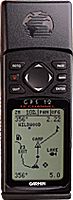
 |
| The position page on the Garmin GPS 12. Note the Lat/Lon coordinates under "Position". |
You could mark coordinates for your great-grandfather's old house. In fact, it might be a good idea just to mark the coordinates of old graveyards and structures, before they get torn down, or covered up by the sands of time. Even if old buildings remain standing, the roads leading to them may wither away, and later generations may have a tough time trying to follow the original directions.
The U.S. Geological Survey has compiled a database of geographic names, including cemeteries, along with their latitude and longitude coordinates. You can enter these coordinates into your GPS device and let it point the way. Most GPS devices require you to be within 500 miles of your destination before it can provide you with directions.
I found that the coordinates presented by the U.S. Geological Survey may not be definitive enough. The coordinates they provide are accurate up to about 100 feet. That's because they don't break down the seconds into tenths or hundreths. Each second in a latitude position represents approximately 100 feet. A GPS device will give you exact coordinates in hundreths, giving you resolution to within 1 foot.
 |
| The compass on the Garmin GPS 12 |
I've even corresponded with a guy who claimed the USGS coordinates are off by about 10 miles. He admitted that not all the geographic names are off, but he maintained that there were too many inaccurate coordinates to be ignored. The information in their database is in fact somewhat old. They don't have many of the newer, and large, cemeteries identified. But that shouldn't affect the accuracy of the coordinates. So far, I haven't run across any grossly inaccurate coordinates.
Even though the GPS is capable of providing 1 foot resolution of accuracy, it will never actually be that accurate. That's because there are so many weather factors that can offset the timing of the signals bouncing back and forth between the device and the satellites. Still, navigation experts claim that you can expect accuracy to within 15 to 40 feet.
Most devices, including the GPS 12, will allow you to create a "trip". A trip is a series of destinations that you wish to visit. Once you have assembled the destinations for your trip, the device will tell you distance, in miles, that separate each destination. On the lower end models, the distance is measured as a straight line, which is not usually practical when driving on roads. But higher end models, with mapping data, can plot a driving course, and provide you with more accurate distance.
 |
| The satellite tracker on the Garmin GPS 12 |
Some people will tell you that the U.S. Government purposely feeds bogus data into the satellites so that they won't be accurate enough for terrorists or foreign aggressors to utilize. Well, that used to be true! The U.S. military had devices that could overcome the inaccuracies. But on May 1, 2000, President Clinton signed an order to cease this practice.
With the popularity of GPS devices in the consumer market, people have been compiling databases of locations. Most of the locations represents trailheads, geographic formations, and such. Many such databases are being published on the web. I'd like to see a similar database of cemeteries, one that is more accurate than the USGS, and includes the tens of thousands of small graveyards that they have left out.
In fact, as a cemetery publisher, I would like to see more cemetery recordists invest in GPS devices and make a habit of marking coordinates. It's probably the best means we have for preserving the locations of abandoned graveyards.
- Steve Paul Johnson