Search Washington Death Records
 Washington Newspapers, Full Search (1854-1984), 109 titles
- Washington Obituary Search - (1985-current)
- Washington Funeral Notices
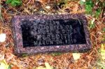 |
| Click photo to enlarge |
Meredith Grave
Pend Oreille County, Washington
SW 1/4 Sec 10 T36N R42E
Lat: 48°37'55"N, Lon: 117°29'43"W
Contributed by Rella Gleaton, Mar 07, 2002 [rella@ultraplix.com]. Total records = 1.
Take Highway 20 East of Colville to Heritage Lake Road. Go South approximately 4 tenths mile to the intersection with Rufus Meadows Rd ( No. 2712 Forest Service Rd) Going left (South) on Rufus Meadows Road 6 and 8 tenth miles, the road climbs up the mountain, where you come to a small meadow on the left. The grave is located about l/4 mile to the S.E. on a wooded knoll.
This Pend Oreille County Pioneer grave is "hidden" in the pine trees on the hillside of "Tiger Mountain" where the family once chose to homestead. The ground is now owned by the State.
Walked and recorded by Jim and Rella Gleaton along with the descendants of the Meredith family who placed the headstone, fenced and tend the grave as well as the neighboring Gangewer headstone. Walked in September 2001.
- Rella Gleaton
Meredith, Vera, b. & d. Mar 24,1919, d/o Samuel & Dora
Browse More Cemetery Records