Search Death Records (United States)
 U.S. Newspapers, 50 State Full Search (1690-present)
- U.S. Obituary Database Search, (1696-present)
- U.S. Birth Announcements Database, (1700s-present)
 |
| Click photo to enlarge |
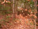
Drummond Point Cemetery
Stanstead County, Quebec
Lat: 45° 12' 03"N, Lon: 72° 11' 16"W
Contributed by Leslie Nutbrown, Nov 05, 2007 ![]() .
Total records = 1.
.
Total records = 1.
From Magog, take route 247 toward Georgeville. After several miles you will pass Oliver Corner and a little cemetery on the left. Keep going until just before reaching a Y in the road (Chemin Gendron) Watch for a narrow road on the right called Chemin de la Pointe Drummond (Drummond Point Road). Take this road down toward lake Memphremagog. The road will branch. Take Peasley Road on the left. Around the first corner on the right is the tiny cemetery with one burial stone.
The story goes that the deceased lived on the other side of the Lake and had small pox and was brought over to the east side of the lake and buried in the woods. In any case, the one stone has been protected by a wooden cover with plexiglass.
I visited this cemetery on Nov 05, 2007 and recorded the one stone as follows.
- Leslie NutbrownPeasley, Francis, d. 30 Nov 1802, aged 35yrs
Browse More Cemetery Records